

Egypt has a strategic geographical location in the middle of the world. It is located in the northeast corner of the African continent. Egypt is in the center of the world. It is the point of convergence of the three old continents Africa, Asia, and Europe. It also overlooks the Mediterranean and Red Sea along with the two Gulfs of Suez and Aqaba.
Naturally, Egypt’s geographic Location empowered it to undertake a significant role in formulating regional and international policies in times of peace. This location also invested it with a unique position in the world. It occupies an Afro-Asian point of convergence. Furthermore, it enabled Egypt to be one of the big players in the Middle East for decades.
Egypt shares international borders with Libya to the west (1115 km), Sudan to the south (1273 km), Gaza Strip (13 km), and Israel to the northeast (255 km). The Mediterranean Sea to the north of Egypt and the Red Sea, the Gulf of Suez, and the Gulf of Aqaba to the east endow the country with a coastline stretching over 1820 miles. Egypt covers an area of 386,660 sq. mi. and is the 30th largest country in the world.
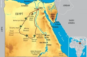
Historically, the Egyptian land has been divided into two sections: Upper Egypt is in the south and Lower Egypt is in the north. People gave the sections these names because the Nile flows from south to north. The river empties into the Mediterranean Sea. Southern Egypt’s landscape contains low mountains and deserts. Northern Egypt has various valleys near the Nile and deserts to the east and west.
The only main river in Egypt is the Nile, fed by the White Nile, the Blue Nile, and the Atbara rivers of central Africa. The Nile enters Egypt near Wadi Halfa in Sudan. It runs to the Mediterranean in Egypt for 1446 km. Egypt receives about 20 cm (8 in) of rain on the Mediterranean coast, and about an inch (3 centimeters) of rainfall each year. The rainy season is winter from December to February. It falls on the north Coast of the Mediterranean Sea.
In the south, Lake Nasser is an artificial reservoir resulting from the construction of the Aswan Dam across the Nile. The old Aswan Dam was constructed at the First Cataract of the Nile in 1902. Therefore, Egyptians built the High Dam between 1960 and 1970..
Egypt is divided into four main geographic regions:
Egypt’s heartland, were the home of one of the principal civilizations of ancient Earth. Egypt has one of the world’s earliest urban civilizations and advanced societies. River Nile is the lifeline for Egyptians. The Nile flows throughout its territory. The Nile Valley is the region extending from the Aswan Dam to the city of Cairo. The region further up north is the Nile Delta. The characteristics of this area are Low-lying, flat, and rich in silt deposits. Hence, the Nile Delta’s agricultural products support the entire country. Formerly, the Nile had seven distributaries creating the fan-shaped valley. the Damietta and the Rosetta carry the Nile waters to the Mediterranean Sea. Egypt also has the Suez Canal, one of the most important international waterways.
Sinai Peninsula is a mountain region. The mountains are usually dry without abundant water resources. Since these mountains depend on the waters of artesian wells, and the rare rainfall. South Sinai has the most sacred places related to the Exodus. On its land, Egyptians built one of the most ancient and important monasteries in the world. It is called Saint Catherine Monastery or Saint Catherine. In Addition, South Sinai has coastal cities. There are the most famous sea resorts and paradisiacal beaches on the Red Sea. For Example, there are Ras Sadr, Sharm El Sheikh, Dahab, Nuweiba and Taba. The South Sinai population is around 165,000.
The Eastern Desert is in the East of the Nile. It extends up to the Red Sea. The mountain range traversing this region is called the Eastern Desert. Shaiyb al-Banat is the highest peak of the mountain range. To the west of the Nile, areas of the Sahara Desert are called the Libyan Desert. The Eastern Desert has massive dunes and eight great depressions. The Eastern desert is uninhabited except for sporadic settlements in the Siwa Oasis near the Qattara Depression. The lowest point of Egypt of 133 meters below sea level is in the Qattara Depression.


